Winter weather warning for areas in western and Northern CT , up through Northeast Massachusetts. This does not include the city of Boston.
Winter weather advisory. For Southern Ct, Most of RI into Southeast Massachusetts. This includes Providence RI and Boston MA.
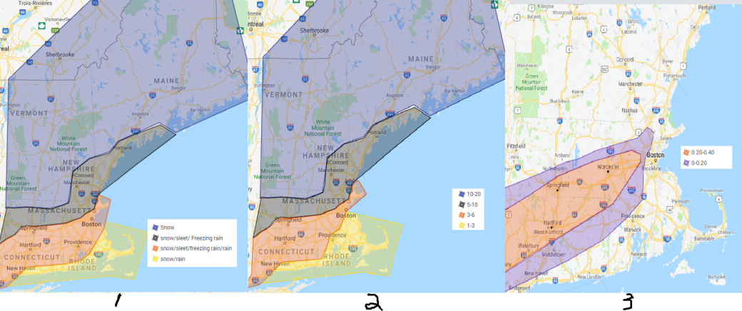
Map 1. Timing. Snow will over spread the region this evening from west to east. The snow will change to rain across the cape and islands and the south shore of CT and RI around mid-night. The snow will change to sleet by day break around the Mass Pike and to I95 corridor. The sleet line will make its furthest decent northward Sunday morning before crashing back towards the coast. Any freezing rain north and west of Boston will likely change back to sleet and snow before ending Sunday afternoon.
Lowered the amounts with 1 to 3 inches of snow/sleet in the yellow region, From the south coast of CT to southern and eastern RI up towards the Boston area as well as the cape and Islands but outer cape and Nantucket could see less than an inch possibly of snow before a change over to rain.
In the region in red, snow and sleet accumulation look to be between 3 to 6 inches, this area is for western and northern CT into South central Mass up along and east of I95 in Northeast Massachusetts. This area looks have more in the way of freezing rain and rain over sleet. Areas east of I95 will likely change to plain rain for a period before changing back to sleet towards the end of the event.
The region in the grey, snow and sleet accumulation 5 to 10 inches. In this region when the snow changes it will likely stay mainly as sleet limiting freezing rain but areas in Northeast Massachusetts up into coastal NH
The region in the purple look to have mainly snow with a chance of sleet mixing in in the south and eastern areas Sunday morning. a general 10 to 20 inches of snow with the highest amounts in the White MTNs up into Central Maine.
Map 3. In the red shaded area there will be a a small sliver of ice accumulation of .2 to .4 of an inch, Best chance of this is in Northern Ct up into South Central Mass. The rest of this region including in the purple shaded areas up to a 0.2 inches of ice is possible. Freezing rain accumulation looks to be limited to the north by sleet and rain to the south.
Level 4/5 road conditions for Northern CT, Western, Central, and Eastern Mass North of the Boston/Providence RI line. Southeast Mass level 2/3 road conditions.
Winds of 10 to 20 with gusts in the 40s. Areas of blowing snow Saturday night and Sunday for those that stay as snow.
There is wiggle room for this to change but at this time this looks like the best bet. Sunday afternoon we will see temperatures crash, precipitation could end as a period of snow for some in eastern mass before the precipitation ends. Everything will become as hard as a rock. I suggest going out there Sunday morning and shoveling the snow and salt the walkways and driveways. I am worried about power outages especially in the areas that get the freezing rain.
Post storm, Very cold temperatures will move in for Sunday night and wind chills look be be below -10 degrees. Temperatures look to remain in the single digits on MLK day with wind chills -10 degrees and colder. Temperatures look to moderate for our next chance of precipitation but details on this will have to wait until after this low pressure.
Forecast for the Merrimack Valley
Tonight. Heavy snow developing. Chance of sleet south near day break. Lows in the upper 10s to low 20s. Becoming breezing. Areas of blowing snow.
Sunday. Snow, sleet and freezing rain. Highs in the mid to upper 20s. Breezy. Areas of blowing snow north. Temperatures dropping. Total Snow and sleet accumulation of 5 to 10 inches with locally higher amounts north. Locally lower amounts south possible.
Sunday night. Cold, Lows around 0, wind chills 10 to 20 below. Mostly to partly cloudy.. Chance of snow showers north.
Monday. Cold. Breezy. Mostly to partly sunny, Highs in the single digits. Wind chills 10 to 20 below.
Monday night. Mainly clear, lows around 0
Tuesday. Sunny, warmer with highs in the low to mid 20s.
Tuesday night. Partly cloudy lows in the low to mid 10s.
Wednesday. cloudy, Chance of rain showers. Highs in the 30s
Wednesday night Cloudy. Chance of rain and/or snow showers, lows in the low to mid 30s.
Thursday. Partly to mostly cloudy. Rain/or showers in the afternoon. Highs in the mid 30s to low 40s.
Thursday night. chance of rain and/or snow showers, lows in the low to mid 30s
Friday. Mostly cloudy chance of rain and/or snow showers. Highs in the low to mid 30s.
NOTE: Wednesday to Friday is not a high forecast. There are many questions on this period of time, details on this won’t come out until probably Monday. Just know throughout the second half of the week there is a chance of precipitation favoring a warmer solution.
Long range: Possible system impacts the region Second half of next weekend into Monday of next week but we all saw what this storm has done.
