Winter weather precaution for Friday has been canceled: The disturbance that was going to be an advertiser for the weekend event on Friday has become a non-event. Snow showers will over spread the region pre-dawn Friday morning and last through Friday Morning before ending southwest to northeast. Snowfall will be in the way of 0 to 1 inch. It just does not have enough juice for it to give us anything.
Winter weather Precaution for Saturday night through Sunday night has been upgraded to Winter Weather Watch. Going from left to right. Map of watch/precaution; current thoughts on precipitation; preliminary snowfall map;road conditions.
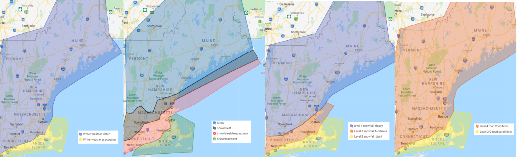
First map: Winter weather watch issued for the areas shaded in blue. (Maine, New Hampshire, Vermont, western/central/northeast/interior southeast mass, Northern Rhode Island, Northern and western CT..
Winter weather precaution for Coastal CT, Southern RI and Southeast mass including the cape and the islands.
Map 2: Models are still adjusting and will continue to shift between warmer and colder solutions. Everyone looks to start as snow Saturday evening and it could come down heavy. The exception look to be the Cape and Islands that change over to sleet and then rain rather quickly. At this time I feel that the rain line could make it up to the Boston and Providence line before being pushed back. This could be in the form of freezing rain in parts of interior southeast Mass. From Southwest CT up into Northeast CT, to South Central Mass up into the 495 corridor in Northeast Massachusetts the snow looks to change over to an icy mix of sleet, freezing rain and snow at some point Sunday before changing back to snow. The best chance of Ice accretions of .2 to .3 of an inch is Northern Ct up into South Central Massachusetts around the Massachusetts turnpike up into interior northeast Massachusetts. From the New Hampshire sea coast to Lowell, to Worcester to Hartford points north. It looks to be Snow changing to a mix of snow/sleet with it possibly mixing in with freezing rain in the southern areas by the cities. The usual colder locations of Massachusetts in Northwest and North central Mass should remain all snow with some sleet possibly mixing in at times as VT, NH remain all snow as seen on the map. People should be hoping for sleet and snow over the freezing rain.
Third map: Snowfall map. This is a preliminary snowfall map classified by the scale range under the scale tab above. Current thoughts is heavy snowfall for areas in western and northern Ct; western, central and northeast Massachusetts up into VT, NH and Maine. Areas in the southern part of this range looks to get a very good dump of snow before any change over happens.
A moderate snowfall is expected at this time for Southern CT into northern RI up into the Boston area this includes the cities of Boston and Providence. This is mainly do to warm air aloft changing the snow to sleet and freezing rain. The further north and west you are the higher the snowfall.
A light snowfall is expected from southern CT to SE Massachusetts with the light snowfall possible over the Cape and Islands. At this time the Cape and Islands look to change rather quickly limiting any snowfall at the start. This system could end as snow depending on how fast the precipitation exits even for the Cape and Islands.
Last map. Road conditions are expected to be treacherous, especially areas that change to sleet and freezing rain. Level 4 road conditions are expected for most of New England except areas of Coastal CT, portions of southern RI , South coast, Cape and Islands.
Timing as of right now snow starts after 5pm with most having snow by 9pm Saturday evening. Snow will start and could become heavy rather fast and with the cold ground won’t take much for it to start accumulating.
There could be a lot of people upset on Sunday when they don’t have power do to the snow and Ice for NFL Championship Sunday I think I have a solution but we shall see Also for Kansas City weather. Game time weather as of right now. Partly cloudy, temperatures in the 10s. its not going to be overly cold as people first thought.
There will be an update later tonight.
